
 Latest News
Content with tag teledetección .
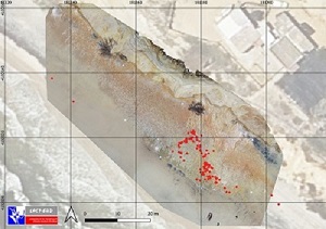
 Drones and topographic models to identify and analyze Neanderthal footprints on Matalascañas beach
When remote sensing and field approaches combine
 Realización de figuras tipo mapa en artículos científicos, 3ªparte
David Aragonés, técnico del LAST-EBD, laboratorio de Sistemas de Información Geográfica (SIG) y Teledetección de la Estación Biológica de Doñana, CSIC, imparte un curso sobre realización de figuras...
Realización de figuras tipo mapa en artículos científicos, 1ªparte
David Aragonés, técnico del LAST-EBD, laboratorio de Sistemas de Información Geográfica (SIG) y Teledetección de la Estación Biológica de Doñana, CSIC, imparte un curso sobre realización de figuras...
— 5 Items per Page