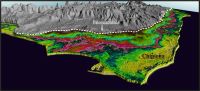
A new study reveals the existence of an ancient coastal plain today located between the towns of Rota, Sanlúcar de Barrameda and Chipiona in the province of Cadiz, in southern Spain
The landscape in Late Plaistocene, when sea levels were 7-8m above the current one, could be similar to Doñana
Scientists from the University of Huelva, the University of Cadiz and the Doñana Biological Station – CSIC have identified an extensive Late Pleistocene coastal plain, from 130.000 years ago, on the northwestern coast of the province of Cadiz, in southern Spain. At that time, this area could be similar to Doñana, with the presence of beaches, lagoons and marshes. The study has recently been published in the scientific journal Geomorphology.
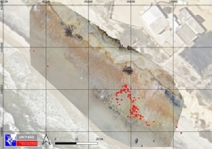
The detection of these geological formations has been possible through the geomorphological analysis of aerial images and 3D digital models, carried out by the GIS and Remote Sensing Laboratory of the Doñana Biological Station. Sedimentary and chronological analyses were carried out to date the age of the formation and know its geological characteristics.
The results have shown how high the sea level rose in this area 130,000 years ago. During this time, the sea in the Gulf of Cadiz would have been between 7 and 8 meters above the current sea level, in line with what other studies have revealed. The sea would have traced a cliff that is visible today between 1.5 and 3 km inland on the areas of Jerez, Sanlucar de Barrameda and Chipiona.
"When the sea level stabilized, an extensive plain was formed in this area characterized by sandy barriers, ponds, and protected marshes, similar to the current coastal arrows of Doñana and Algaida at the mouth of the Guadalquivir river", explains Antonio Rodríguez Ramírez, a researcher from the University of Huelva. "This wide sandy plain started growing towards the northwest", he adds. The development of dunes were scarce, according to the study, making the landscape more similar to the area of the Navazos de Marismillas, in the Doñana National Park.
This formation would have been formed during the previous interglacial, the warm climatic interval immediately preceding the present one, which took place between 130,000 and 80,000 years ago. From here until the last glaciation, about 20,000 years ago, the sea level began to fall to a minimum of about 100 meters below the present sea level, uncovering a broad marine platform. On this platform, sediments continued to accumulate over time, forming new sandy barriers and beaches. When the sea level began to rise again after the end of the Ice Age, this platform was eroded, leaving only a small area, which is the one that has been studied in this research.
"If the sea level continues to rise until it reaches the 7 or 8 meters above the current sea level, as 130,000 years ago, an important part of the currently emerged land could be underwater, as we have been able to visualize in the study", explains the researcher Antonio Rodríguez Ramírez. "Once again, the past shows us the path to a foreseeable future".
Referencia:
A. Rodríguez-Ramírez, F.J. Gracia, J.A. Morales, D. García, E. Mayoral, 2024. A Late Pleistocene coastal plain pertaining to MIS 5 in the Gulf of Cádiz (mouth of the Guadalquivir River, SW Iberia). Geomorphology. https://doi.org/10.1016/j.geomorph.2024.109096
https://doi.org/10.1016/j.geomorph.2024.109096 A 130,000 years-old Doñana discovered on the coast of Cadiz