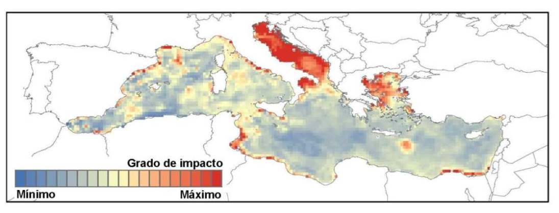
A study analysed and distributed the existing information on several impacts that are simultaneously affecting the Mediterranean Sea: from climate impacts like the rise of temperatures in the sea, to the fishing pressure on natural resources or changes in physical and chemical conditions. The result is a map of the places that are most affected by human activity such as the Adriatic Sea, the Aegean Sea, the African coast and the Catalan sea, among others. According to the researchers, this information will enable identifying areas that need local action to minimize the impacts of a global problem such as climate change. The study is framed within the concept of Safe Operating Spaces (SOS), which determines a multidimensional space in which we would find an ecosystem and is delimited by several kinds of impacts such as pollution, fishing, or the temperature of water. In order for this ecosystem to be in the right conditions, magnitude of the impacts should not exceed certain thresholds, therefore, if the magnitude of an impact increases, the thresholds of the others decrease and vice-versa. By delimiting a SOS out of climate and human impacts, when reducing anthropic pressure, the threshold for climate impacts would increase and therefore, the ecosystem's ability to resist environmental impacts related to climate change would increase. To spatially delimit the potential impacts that would affect the Mediterranean Sea, several methodologies and databases such as the largest temporary series of remote sensing –satellite images- that provide data on the temperature of the marine surface were combined. Data on the distribution of the fishing pressure provided by Global Fishing Watch were also used. According to the study, those areas that are affected by human impact would be more potentially vulnerable to climate change. In particular, the results show that there are certain areas that are more vulnerable such as the Adriatic Sea, the Aegean Sea, the African coast and the Catalan sea, where fishing intensity is high. If we add the rise of temperatures in the sea, caused by global warming, the result is that there will be species of commercial interest like the sardine, which will be particularly affected, since they are very sensitive to the rise of temperatures. Knowing how to distribute these threats can help management of several activities like fishing. For instance, it can regulate these activities in affected areas or move fishing to areas that are less affected by other threats. Local administrations cannot fight climate change by themselves, since it requires the consensus and action of all the international community. However, working on other local impacts, the "vulnerability" of certain areas and ecosystems regarding the climate change could be reduced. In addition to fighting global warming, potential measures of mitigation could consist in managing local impacts. informacion[at]ebd.csic.es: Ramírez et al (2018) Spatial congruence between multiple stressors in the Mediterranean Sea may reduce its resilience to climate impacts. Scientific Reports 8:14871 DOI 10.1038/s41598-018-33237-w
https://www.nature.com/articles/s41598-018-33237-w Identificando las áreas más amenazadas del mar Mediterráneo