

 Las altas temperaturas están provocando que las lagunas y las marismas de Doñana pierdan agua rápidamente

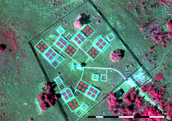
Although many climate research experiments are providing valuable data, long-term measurements are not always affordable. In the last decades, several facilities have secured long-term experiments, but few studies have incorporated spatial and scale effects. Most of them have been implemented in experimental agricultural fields but none for ecological studies. Scale effects can be assessed using remote sensing images from space or airborne platforms. Unmanned aerial vehicles (UAVs) are contributing to an increased spatial resolution, as well as becoming the intermediate scale between ground measurements and satellite/airborne image data. This paper assessed the applicability of UAV-borne multispectral images to provide complementary experimental data collected at point scale (field sampling) in a long-term rain manipulation experiment located at the Kiskun Long-Term Socio-Ecological Research (LTSER) site named ExDRain to assess the effects on grassland vegetation. Two multispectral sensors were compared at different scales, the Parrot Sequoia camera on board a UAV and the portable Cropscan spectroradiometer. The NDVI values were used to assess the effect of plastic roofs and a proportional reduction effect was found for Sequoia-derived NDVI values. Acceptable and significant positive relationships were found between both sensors at different scales, being stronger at Cropscan measurement scale. Differences found at plot scale might be due to heterogeneous responses to treatments. Spatial variability analysis pointed out a more homogeneous response for plots submitted to severe and moderate drought. More investigation is needed to address the possible effect of species abundance on NDVI at plot scale contributing to a more consistent representation of ground measurements. The feasibility of carrying out systematic UAV flights coincident or close to ground campaigns will certainly reveal the consistency of the observed spatial patterns in the long run. informacion[at]ebd.csic.es: Díaz-Delgado ET AL (2019) Enhancement of ecological field experimental research by means of UAV multispectral sensing. Drones https://doi.org/10.3390/drones3010007
https://www.mdpi.com/2504-446X/3/1/7