

 Las altas temperaturas están provocando que las lagunas y las marismas de Doñana pierdan agua rápidamente


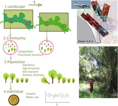
Implementing long-term monitoring programs that effectively inform conservation plans is a top priority in environmental management. In floodplain forests, historical pressures interplay with the complex multiscale dynamics of fluvial systems and require integrative approaches to pinpoint drivers for their deterioration and ecosystem services loss. Combining a conceptual framework such as the Driver-Pressure-State-Impact-Response (DPSIR) with the development of valid biological indicators can contribute to the analysis of the driving forces and their effects on the ecosystem in order to formulate coordinated conservation measures. This study evaluates the initial results of a decade of floodplain forest monitoring. The DPSIR framework was adopted to summarize the main drivers in land use and environmental change, the effects on biological indicators of foundation trees were analyzed, and the consistency of the main drivers and their effects at two spatial scales were compared. The monitoring program was conducted in one of the largest and best preserved floodplain forests in SW Europe located within Doñana National Park (Spain) which is dominated by Salix atrocinerea and Fraxinus angustifolia. The program combined field surveys on a network of permanent plots with several remote sensing sources. The accuracy obtained in spectral classifications allowed shifts in species cover across the whole forest to be detected and assessed. However, remote sensing did not reflect the ecological status of forest populations. The field survey revealed a general decline in Salix populations, especially in the first five years of sampling –a factor probably associated with a lag effect from past human impact on the hydrology of the catchment and recent extreme climatic episodes. In spite of much reduced seed regeneration, a resprouting strategy allows long-lived Salix individuals to persist in complex spatial dynamics. This suggests the beginning of a recovery resulting from recent coordinated societal responses to control excessive water extraction in the catchment, highlighting the need for continuing long-term monitoring. The DPSIR framework proved useful as a conceptual tool in analyzing the entire environmental system, while both field and remote sensing approaches complemented each other in quantifying indicator trends, improving the monitoring design and informing conservation plans. información[at]ebd.csic.es: Rodríguez-González et al (2017) Long-term monitoring for conservation management: Lessons from a case study integrating remote sensing and field approaches in floodplain forests J Environ Manage http://dx.doi.org/10.1016/j.jenvman.2017.01.067
http://www.sciencedirect.com/science/article/pii/S0301479717300853