

 Las altas temperaturas están provocando que las lagunas y las marismas de Doñana pierdan agua rápidamente
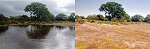

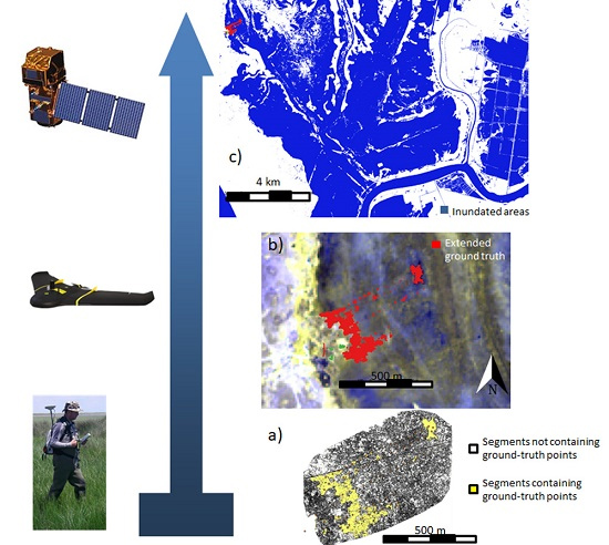
Long-term ecological research (LTER) sites need a periodic assessment of the state of their ecosystems and services in order to monitor trends and prevent irreversible changes. The ecological integrity (EI) framework opens the door to evaluate any ecosystem in a comparable way, by measuring indicators on ecosystem structure and processes. Such an approach also allows to gauge the sustainability of conservation management actions in the case of protected areas. Remote sensing (RS), provided by satellite, airborne, or drone-borne sensors becomes a very synoptic and valuable tool to quickly map isolated and inaccessible areas such as wetlands. However, few RS practical indicators have been proposed to relate to EI indicators for wetlands. This work suggests several RS wetlands indicators to be used for EI assessment in wetlands and specially to be applied with unmanned aerial vehicles (UAVs). The applicability of multispectral images captured by UAVs over two long-term socio-ecological research (LTSER) wetland sites are also assessed to provide detailed mapping of inundation levels, water turbidity and depth as well as aquatic plant cover. An empirical approach is followed to find linear relationships between UAVs spectral reflectance and the RS indicators over the Doñana LTSER platform in SW Spain. The method assessment was carried out using ground-truth data collected in transects. The resulting empirical models were implemented for Doñana marshes and can be applied for the Braila LTSER platform in Romania. The resulting maps are a very valuable input to assess habitat diversity, wetlands dynamics, and ecosystem productivity as frequently as desired by managers or scientists. Finally, authors also examined the feasibility to upscale the information obtained from the collected ground-truth data to satellite images from Sentinel-2 MSI using segments from the UAV multispectral orthomosaic. A close multispectral relationship between Parrot Sequoia and Sentinel-2 bands was found, which made it possible to extend ground-truth to map inundation in satellite images. informacion[at]ebd.csic.es: Díaz-Delgado et al (2019) Rapid assessment of ecological integrity for LTER wetland sites by using UAV multispectral mapping. Drones https://doi.org/10.3390/drones3010003
https://www.mdpi.com/2504-446X/3/1/3