

 Open Call for Research Projects in ICTS-Doñana!


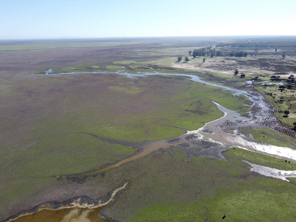
These values are slightly below average for these dates. The areas with the greatest flooding are El Rocío and los Sotos.
The recovery of the Santa Olalla lagoon is slow, with only 9,6% of its surface area flooded.
The first autumn rains begin to flood the Doñana marshes again, as they do every year at this time of year. The flooding of the marshes and temporary lagoons in the park is part of the usual hydrological cycle of these ecosystems. To assess their current state, the Doñana Biological Station - CSIC, through the ICTS-Doñana Biological Reserve and the GIS and the Laboratory of GIS and Remote Sensing, collected rainfall data from weather stations in the park and the surrounding area, and used the latest satellite images and drone flights to estimate the flooded area.
More precipitation in the surrounding area than within the Park
Although the municipalities around Doñana have experienced slightly above-average rainfall, the situation is different within the National Park. The Almonte and Chipiona stations of the Andalusian Agroclimatic Information Network recorded accumulated rainfall of 125 and 131 litres per square metre in September and October, values which are considerably above the average for the last 20 years.
However, the data from the Palacio de Doñana station, which is located in the heart of the National Park, show a much lower rainfall with 72 l/m2, which is below the average for the last 20 years. Likewise, the six automatic weather stations in the ICTS - Doñana Biological Reserve, which provide continuous data every five minutes, give an average rainfall in September and October of 87.7 l/m2, far below the precipitation registered in Almonte and Chipiona.
Low flooding of the marsh
The differences in rainfall around Doñana and within the park have generated different situations. The Sentinel 2 satellite images of 7 November, which clearly show the state of flooding of the marshes without clouds, show that the first areas to be flooded were the El Rocío and Los Sotos marshes, with a flooded surface area of 188.8 ha. These images also allow us to estimate that the total flooded area of the Doñana marshes is currently around 537.8 hectares, which represents 1.8% of its total surface area. This value is slightly below average at this time of year. In addition, some flooded areas have been detected in the Lucio del Rey and the Lucio de Veta Lengua, as well as on the boundary of the marsh with the river and the Brazo de la Torre, although these are due to tidal influence. The rainfall to date is allowing the clays that form the marsh substrate to hydrate, and additional rainfall will be necessary to increase the total flooded area.
Santa Olalla flooded 9.6 % of its total surface
The situation in the lagoons is different. While the marshes are located on clay soils and are fed only by surface water, the Doñana lagoon system is located in a sandy area and their flooding depends on the water in the aquifer and its water table. It is when the aquifer is recharged by rainfall and the water reaches the surface that the lagoons begin to flood.
At this time the Santa Olalla lagoon is also showing the first signs of recovery. Santa Olalla used to be the largest permanent lagoon in Doñana. However, the overexploitation of the aquifer and the low levels of rainfall that have been recorded for more than ten years ended up drying it up completely during the last two consecutive summers, which has never happened since records have been kept.
As of 7 November, the lagoon was approximately 7 cm deep measured on the eastern scale. The drone imagery estimates a flooded area of 4.7 ha, or 9.6% of its maximum area, which is estimated at 49 ha.
http://www.ebd.csic.es/documents/10184/315629/Inundaci%C3%B3n+Marisma.+7+de+noviembre+de+2023/3f63530f-24b8-4faf-bb5c-b69139b23489