

 Las altas temperaturas están provocando que las lagunas y las marismas de Doñana pierdan agua rápidamente


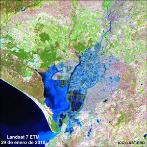
This paper presents a semi-automatic procedure to discriminate seasonally flooded areas in the shallow temporary marshes of Doñana National Park by using a radiommetrically normalized long time series of Landsat MSS, TM, and ETM+ images (1974–2014). Extensive field campaigns for ground truth data retrieval were carried out simultaneous to Landsat overpasses. Ground truth was used as training and testing areas to check the performance of the method. Simple thresholds on TM and ETM band 5 worked significantly better than other empirical modeling techniques and supervised classification methods to delineate flooded areas at Doñana marshes. About 391 flood masks were used to reconstruct historical spatial and temporal patterns of Doñana marshes flooding, including hydroperiod. Hydroperiod historical trends were used as a baseline to understand Doñana's flooding regime, test hydrodynamic models, and give an assessment of relevant management and restoration decisions. The historical trends in the hydroperiod of Doñana marshes show two opposite spatial patterns. While the north-western part of the marsh is increasing its hydroperiod, the southwestern part shows a steady decline. Anomalies in each flooding cycle allowed to assess recent management decisions and monitor their hydrological effects. informacion[at]ebd.csic.es: Díaz-Delgado et al (2016) Long-term monitoring of the flooding regime and hydroperiod of Doñana marshes with Landsat time series (1974–2014). Remote Sens doi:10.3390/rs8090775