Remote sensing, a key tool for monitoring and assessing the health of Doñana's ecosystems
Doñana stands out for its potential to become an international calibration and validation site for remote sensing products
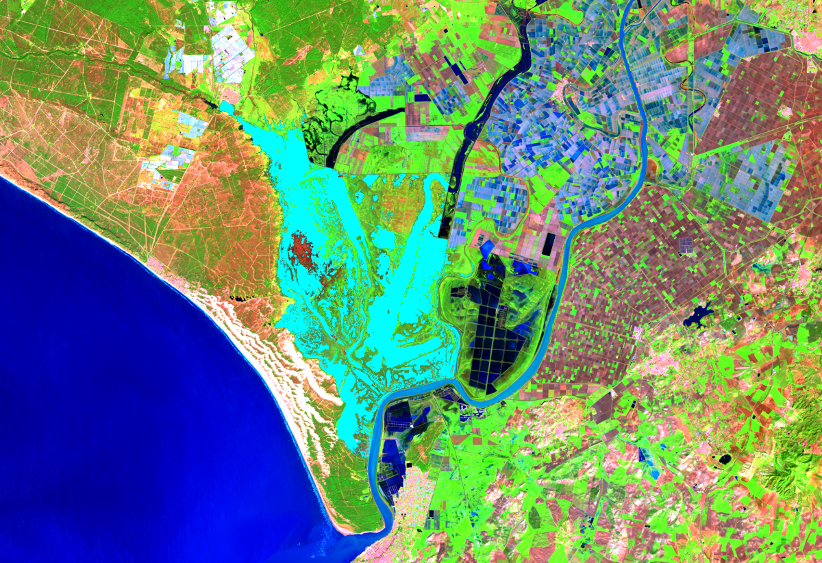
Landsat 8 satellite image of 30 January 2025, showing the flooded areas of the marsh in light blue, which allows us to estimate the total surface area. Prepared by: GIS and Remote Sensing Laboratory of the Doñana Biological Station – CSIC
Remote sensing is a technique that uses satellite or drone imagery to observe changes on Earth's surface and is becoming an essential tool for advancing the understanding of ecosystems and improving their conservation. The Doñana Biological Station – CSIC is actively working in this field to enhance the monitoring and assessment of Doñana’s ecosystems, complementing traditional on-the-ground environmental monitoring.
Since 2004, through its GIS and Remote Sensing Laboratory (LAST-EBD), the Doñana Biological Station has been using remote sensing to identify and track changes and trends in the Doñana Natural Area at a landscape scale. This monitoring allows researchers to assess the dynamics of key geomorphological processes, such as dune system movement, coastline changes, and marsh sedimentation. It is also used to map the flooding of Doñana’s marshes and ponds, enabling scientists to estimate the flooded area at any given time, track the number of days each area remains flooded per year, and detect anomalies.
"Using remote sensing for continuous monitoring enables the detection of changes in biodiversity, land use, flooded areas, or fire-affected zones. This can be done rapidly, even in remote or hard-to-access areas, while covering large regions," explains Pedro J. Gómez Giráldez of LAST-EBD. "Moreover, data collection is non-invasive and non-destructive, allowing us to study ecosystems without directly influencing them”.
In the field of biodiversity, Landsat satellite images are used to create detailed maps of the National Park’s major vegetation formations and to track land-use changes, as well as landscape fragmentation and connectivity. More recently, the Doñana Biological Station – CSIC has incorporated vegetation phenology monitoring, analyzing the growth cycle based on key indicators such as start and end dates, total duration, and peak growth—factors increasingly affected by global change. This phenological data is complemented by gross primary production measurements, highlighting the remarkable resilience of some of Doñana’s characteristic formations, such as the shrublands covering the aeolian mantle and the juniper woodlands.
“Remote sensing reduces costs and effort compared to traditional field methods, enabling the analysis of remote or hard-to-access areas,” explains Ricardo Díaz-Delgado, researcher at the Doñana Biological Station and coordinator of Environmental Monitoring at ICTS Doñana. “It also serves as a historical source of information that can be used as a reference for planning and implementing restoration projects and long-term monitoring programs.”amas de seguimiento a largo plazo”
Assessing the Success of Restoration Projects
The Doñana Biological Station – CSIC continues to advance research to integrate new techniques and enhance remote sensing applications. In one of its most recent studies, researchers analyzed the use of hyperspectral sensors to assess the success of wetland ecological restoration. These sensors capture images across the entire optical electromagnetic spectrum, allowing for detailed mapping of wetland characteristics.
The study was conducted in Finca Caracoles, an area restored and incorporated into Doñana National Park in 2004, where 96 experimental lucios (marsh lagoons) were created. “This research demonstrated the ability of spectral imagery to monitor water bodies, even very small ones, by detecting changes in water depth, turbidity, and chlorophyll concentration,” explains Cristina Coccia, researcher and lead author of the study.
‘This will allow us to assess the success of restoration projects, but also, for example, the impact of prolonged droughts in the future,’ explains Díaz-Delgado
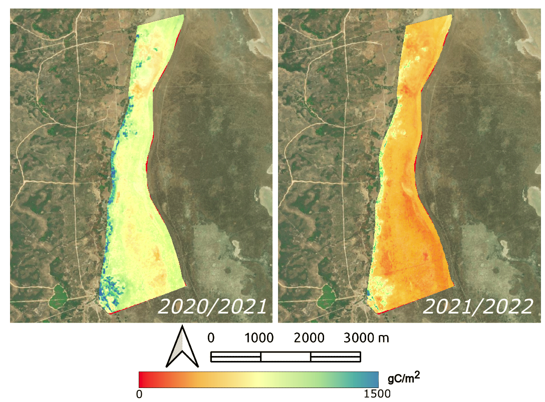
Recent studies at the Doñana Biological Station have further confirmed the effectiveness of remote sensing techniques in generating maps of key variables that enhance our understanding of the environmental services provided by Doñana’s ecosystems. One such variable is gross primary production—the total amount of energy absorbed by plants and other photosynthetic organisms as they capture sunlight and convert it into organic matter through photosynthesis. This serves as a crucial indicator of carbon assimilation, an essential ecosystem service in the context of climate change.
In a study published earlier this year, the research team successfully produced periodic maps of primary production in Doñana’s shrublands and marsh vegetation. These maps were validated using in situ data from ICTS Doñana’s flux towers, with a mean error of less than 0.5 gC/m², confirming the accuracy of this method. “Currently, similar products provided by European programs like Copernicus do not include an estimate of the associated error,” explains Díaz-Delgado.
Doñana, an international benchmark in remote sensing calibration and validation
These investigations also highlight the need to continue acquiring data in situ, in the field, in order to validate this information. ‘The ICTS Doñana facilities have a great capacity to turn the protected area into an international benchmark for the calibration and validation of remote sensing products in natural environments,’ says Ricardo Díaz-Delgado.
In this sense, the Doñana Biological Station, through LAST-EBD, is participating in the validation of the products of the European Space Agency's Fluorescence Explorer-Sentinel 3 (ESA Flex-3) mission, which aims to detect the fluorescence of vegetation with a pixel resolution of 300 x 300. This will make it possible to monitor the health of vegetation, assess its primary productivity and understand how it is affected by extreme factors such as drought or extreme temperatures, which are becoming increasingly common as a result of climate change
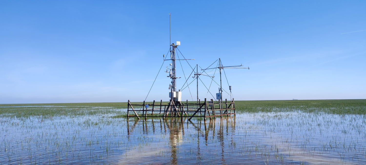
Fuenteduque gas exchange and remote sensing product validation station in the marsh. Photo: Ricardo Díaz-Delgado
The use of remote sensing in environmental monitoring is steadily advancing, driven by continuous technological advances. However, remote sensing still has its challenges. ‘In general, there are the limitations of remote sensing itself, such as the large volume of data to be handled, the dependence on cloud-free imagery and the validation of the products,’ explains Gómez Giráldez. "In natural environments, the biggest challenge is the great heterogeneity present in ecosystems in terms of relief or plant species. The most normal thing in our case is that in one pixel there is information on several plant and soil species, something that does not happen so often in other areas, such as agriculture, for example," he concludes.
This heterogeneity requires a greater effort to calibrate and validate the products provided by Earth Observation space missions such as the FLEX mission, and for this, Doñana is an ideal area as it also has a high level of monitoring. ‘Natural environments, such as the Doñana Natural Area, act as sentinels of global change by reflecting patterns related to the different drivers of change such as prolonged drought, high temperatures or the increase in atmospheric CO2’, concludes Ricardo Díaz-Delgado.
This communication is part of the PENELOPE project, “Enhancing the value of the Doñana E-infrastructure for the long-term monitoring of natural processes” (Ref: ICT2021-006767), funded by the Spanish Ministry of Science and Innovation through the Recovery, Transformation and Resilience Plan, European Union – NextGenerationEU funds.
Reference
Coccia, Cristina, Eva Pintado, Álvaro L. Paredes, David Aragonés, Daniela C. O’Ryan, Andy J. Green, Javier Bustamante, and Ricardo Díaz-Delgado. 2024. “Modelling Water Depth, Turbidity and Chlorophyll Using Airborne Hyperspectral Remote Sensing in a Restored Pond Complex of Doñana National Park (Spain).” Remote Sensing 16 (16). 2996. doi: https://doi.org/10.3390/rs16162996
Gómez-Giráldez, Pedro J., Jordi Cristóbal, Héctor Nieto, Diego García-Díaz, and Ricardo Díaz-Delgado. 2024. “Validation of Gross Primary Production Estimated by Remote Sensing for the Ecosystems of Doñana National Park through Improvements in Light Use Efficiency Estimation.” Remote Sensing 16 (12). 2170. doi: https://doi.org/10.3390/rs16122170
Gómez-Giráldez, Pedro J., Marcos Jiménez, Ma Pilar Cendrero-Mateo, Shari Van Wittenberghe, Juan José Peón, Adrián Moncholí-Estornell, Jesús Delegido, Jose F. Moreno, and Ricardo Díaz-Delgado. 2024. “The Spafleximp Project: Spanish Flex-S3 Mission Calibration and Validation Plan Implementation.” In IGARSS 2024 - 2024 IEEE International Geoscience and Remote Sensing Symposium, 296–300. doi: https://doi.org/10.1109/IGARSS53475.2024.10640946 .