Un análisis preliminar realizado por la Estación Biológica de Doñana (EBD-CSIC) estima que el reciente incendio registrado en el Parque Nacional de Doñana ha afectado a alrededor de 500 hectáreas, con predominio de niveles de severidad baja y moderada-baja y con una extensión reducida de áreas de alta severidad.
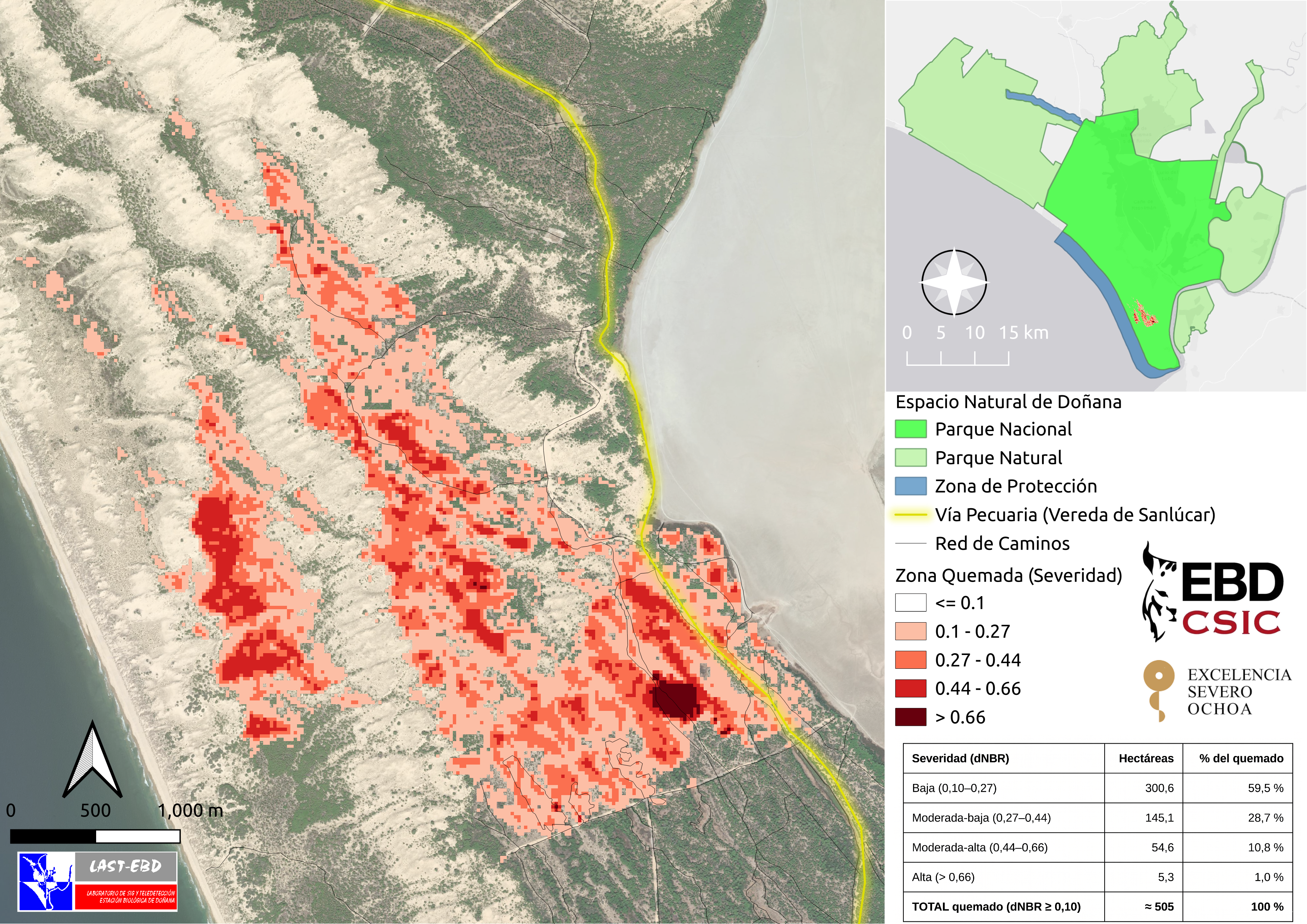
Mapa de severidad del incendio de Doñana. Diego García Díaz / LAST-EBD
Un análisis preliminar realizado por el Laboratorio de SIG y Teledetección de la Estación Biológica de Doñana - CSIC estima que el incendio declarado el 24 de mayo en la finca de Marismillas, en el corazón del Parque Nacional de Doñana, y que se dio por controlado la tarde del 27 de mayo, ha afectado a alrededor de 500 hectáreas.
El incendio, que se ha extendido principalmente sobre masas de pinar mediterráneo y sistemas dunares asociados de muy alto valor ecológico, ha sido evaluado mediante imágenes satelitales Sentinel-2 del programa Copernicus de la Agencia Espacial Europea.
Según los resultados preliminares, la mayor parte del área quemada presenta severidad baja o moderada-baja, patrón compatible con incendios de sotobosque en masas de pinar mediterráneo. Las zonas de severidad alta aparecen restringidas a áreas muy concretas y representan una proporción reducida de la superficie total afectada.
El análisis muestra que las áreas afectadas se distribuyen principalmente a lo largo de los corrales interdunares, depresiones alargadas ocupadas por pinares y matorral mediterráneo, orientadas en dirección noroeste-sureste.
Además, las dunas activas y superficies arenosas, libres parcialmente de vegetación inflamable, han actuado en numerosos sectores como barreras naturales frente al fuego, limitando la propagación del incendio. El incendio tampoco alcanzó las zonas de marisma, donde la abundante presencia de agua en superficie durante esta primavera probablemente ayudó a frenar el avance del fuego.
Por otro lado, las condiciones meteorológicas y, especialmente, la dirección dominante del viento, resultaron determinantes para limitar la extensión final del incendio.
La zona incendiada es hábitat de especies de mamíferos como el lince ibérico, el ciervo, el gamo, el jabalí, el zorro, el meloncillo o la gineta. También alberga aves rapaces, actualmente en época de reproducción, como el milano real, catalogado "En Peligro de Extinción" en el Catálogo Español de Especies Amenazadas, y el águila imperial ibérica, clasificada como "Vulnerable" a nivel global en la Lista Roja de la UICN. Por otro lado, esta zona también acoge flora amenazada, como el enebro costero (del que Doñana constituye uno de los principales núcleos de conservación en España) o el brezo Erica ciliaris, catalogado como «Vulnerable», entre otras muchas especies más.
Consideraciones técnicas:
El análisis ha sido realizado por Diego García Díaz del Laboratorio SIG y Teledetección de la Estación Biológica de Doñana. La metodología empleada se basa en el cálculo del índice NBR (Normalized Burn Ratio) y de su diferencia temporal (dNBR), uno de los procedimientos más utilizados internacionalmente para la cartografía de áreas quemadas y evaluación de severidad de incendios forestales.
Es importante señalar que las estimaciones obtenidas tienen carácter preliminar y están condicionadas por la resolución espacial de las imágenes empleadas. En zonas estrechas o heterogéneas, algunos píxeles pueden mezclar superficies quemadas con arena desnuda, reduciendo los valores de severidad observados. No obstante, los resultados proporcionan una primera aproximación robusta y coherente con la dinámica observada sobre el terreno.